Ask any residential general contractor, kitchen remodeler, or tenant improvement (TI) builder what their least favorite project task is, and they will give you the same answer: field measuring existing conditions.
Spending four hours in a hot, dusty house with a 25-foot tape measure, a laser distance meter, and a gridded paper clipboard is not just miserable work—it is prone to catastrophic human error:
- You forgot to measure the distance from the corner to the kitchen window trim.
- You wrote down
14'-6"when the true dimension was11'-6". - The house was built in 1952, and not a single wall is plumb or square.
When the cabinet package arrives eight weeks later and is 3 inches too wide for the opening, or when the structural engineer's proposed LVL beam does not align with the existing bearing wall, the contractor eats thousands of dollars in emergency job-site modifications.
Today, advanced mobile LiDAR sensors built directly into consumer smartphones (iPhone 12 Pro through 16 Pro and iPad Pro) have completely transformed field documentation.
A contractor can walk through a 2,500 sq ft home in 15 minutes, capture hundreds of thousands of spatial survey points with millimeter fidelity, upload the raw scan from their phone, and receive an architecturally squared, permit-ready CAD/BIM floor plan set without ever pulling a tape measure twice.
Here is an in-depth breakdown of the technology, the extraction workflow, and how contractors use Scan-to-CAD to eliminate rework.
1. How Mobile LiDAR Works in the Field
Unlike photogrammetry (which tries to stitch together 2D photographs by matching pixel contrast), the LiDAR scanner in an iPhone Pro emits invisible pulsed laser beams at up to 100,000 pulses per second.
By calculating the Time-of-Flight (ToF)—the exact nanoseconds it takes for light to bounce off a baseboard, wall, or ceiling back to the sensor—the phone creates a real-time 3D point cloud coordinate mesh.
| Production Phase | Scanning & Processing Action | Technical Specifications | Final Permit Deliverable |
|---|---|---|---|
| Phase 1: On-Site Phone Scan (15 Min) | Walk room perimeter with iPhone 12–16 Pro using LiDAR apps (Polycam, Canvas, SiteScape) | Captures 100,000 laser pulses/sec: walls, ceiling heights, window sills, and floor steps | Unified millimeter-accurate spatial mesh |
| Phase 2: Cloud Mesh Processing | Noise filtration, decimation, and orthogonal coordinate alignment | Million-point .E57 / .LAS spatial point cloud sliced at standard +42″ horizontal cutting plane | True orthogonal 90° reference datums |
| Phase 3: Traced CAD Permit Drafting | Senior drafters draft native geometry in AutoCAD, Chief Architect, or Revit | Converts raw point mesh into plumb walls, verified door/window schedules, and dimension strings | Permit-ready 24x36 DWG and PDF drawing sets |
Field Scanning Best Practices
- Walk the Perimeter Smoothly: Hold the device at chest height, tilting slightly upward toward wall-ceiling intersections and downward toward baseboards.
- Open Interior Doors: Keep all passage doors halfway open so the sensor registers door frame reveals and can link adjacent rooms into a single coordinate space.
- Scan MEP Drops & Obstructions: Point the camera upward at soffits, exposed HVAC supply ducts, beam drops, and electrical subpanels so their vertical elevations are captured.
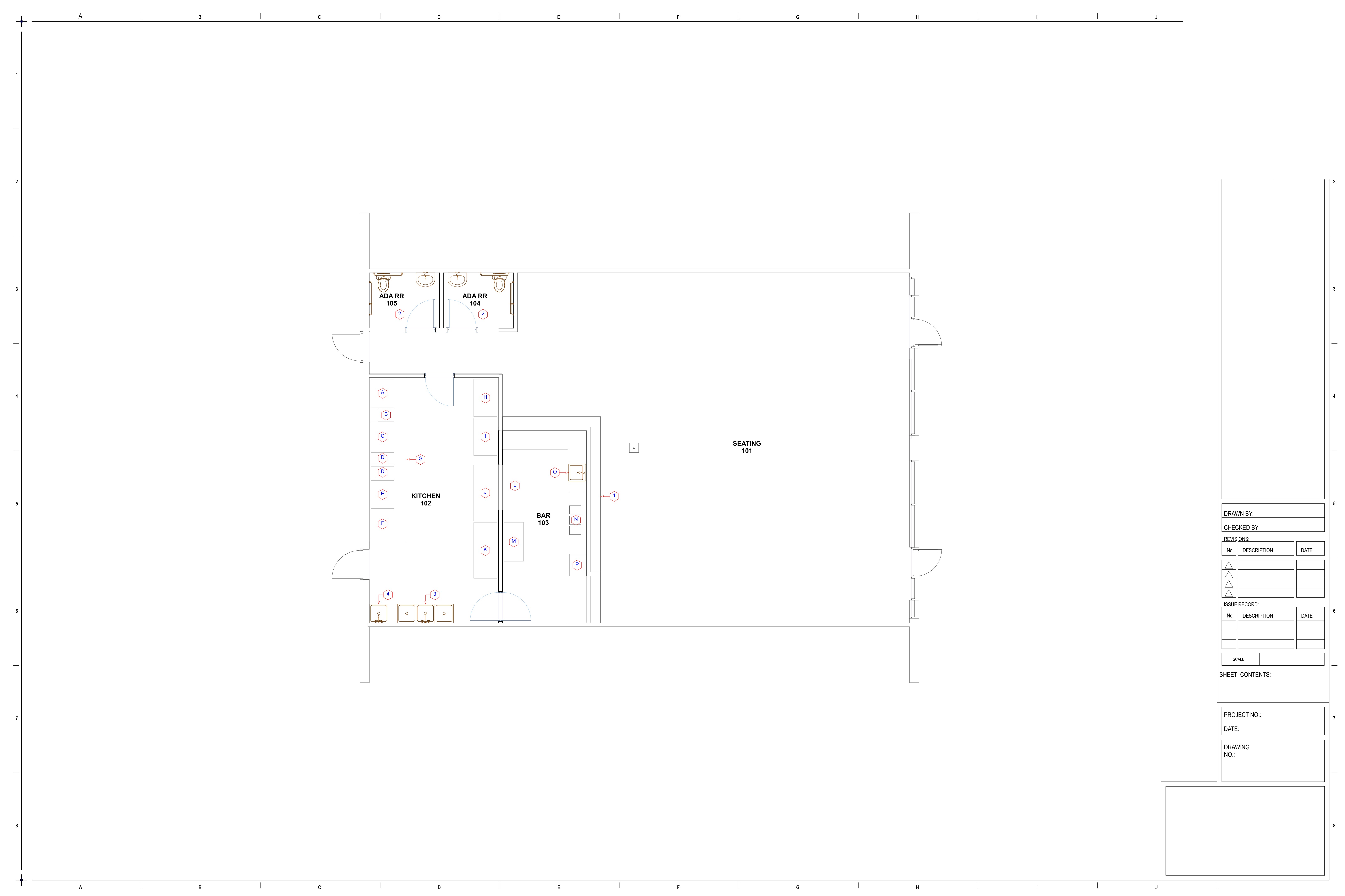
Real Scan-to-CAD as-built documentation generated from point-cloud coordinates, showing precision wall dimensions, door swings, and plumbing fixture clearances.
2. From Raw Point Cloud to Squared CAD Walls: The Drafting Pipeline
A raw 3D mesh is simply a cloud of thousands of floating points. It cannot be directly submitted to a city building department as a blueprint.
To turn a raw scan into a permit-ready CAD drawing, our drafting studio executes a rigorous digital conversion pipeline:
1. Section Plane Slicing
In Revit or AutoCAD, we import the registered point cloud (.e57, .rcp, or .las) and cut a horizontal section plane at 42 inches (+3'-6" AFF) above the finished floor level. This captures wall cores, window sills, door jambs, and cabinetry footprints.
2. Wall Alignment & Squaring
Existing residential buildings—especially historic structures or homes with foundation settlement—rarely have perfectly straight walls. A raw scan might show a wall running at an angle of 89.4 degrees with a 1-inch bow in the drywall.
- If a drafter simply traces the crooked scan lines, the resulting CAD model will have non-parallel walls, making dimensioning and truss placement impossible.
- Our drafters analyze the structural framing logic: we square out walls to true 90-degree orthogonal geometry while maintaining exact measured clear spans at critical fixture locations.
3. Wall Assembly Thickness Identification
By measuring the distance between interior drywall points and exterior cladding points, we determine the true structural wall thickness:
- Interior Partitions: 4-1/2" (2x4 stud with 1/2" drywall each side).
- Exterior Wood Framing: 6-1/2" (2x6 stud with 1/2" OSB sheathing and drywall).
- Historic Masonry / Stucco: 8" to 12" multi-wythe brick or block.
3. Tolerances: What Mobile LiDAR Can and Cannot Do
To use mobile LiDAR effectively, contractors must understand its physical boundaries:
| Scanning Parameter | iPhone / iPad Mobile LiDAR | Terrestrial Tripod Scanner (FARO / Leica) | Traditional Tape & Laser Meter |
|---|---|---|---|
| Equipment Cost | $0 (Already in your pocket) | $25,000 – $65,000 | $150 |
| Typical Setup Time | Instant (Zero setup) | 15–30 minutes per room setup | Instant |
| Field Scan Time (2,500 sf) | 15 – 25 minutes | 3 – 5 hours | 3 – 5 hours |
| Point Accuracy | ±0.25" to ±0.5" (1/4 to 1/2 inch) | ±0.04" (1 millimeter) | ±1" (Accumulated error) |
| Permit Feasibility | 100% compliant for residential remodels & TIs | Required for historic preservation & civil bridges | Prone to missed dimensions |
For 98% of residential additions, kitchen remodels, basements, ADUs, and commercial retail TIs, a ±1/4" tolerance is well within standard rough-carpentry framing margins (where a 2x4 stud itself varies by 1/8").
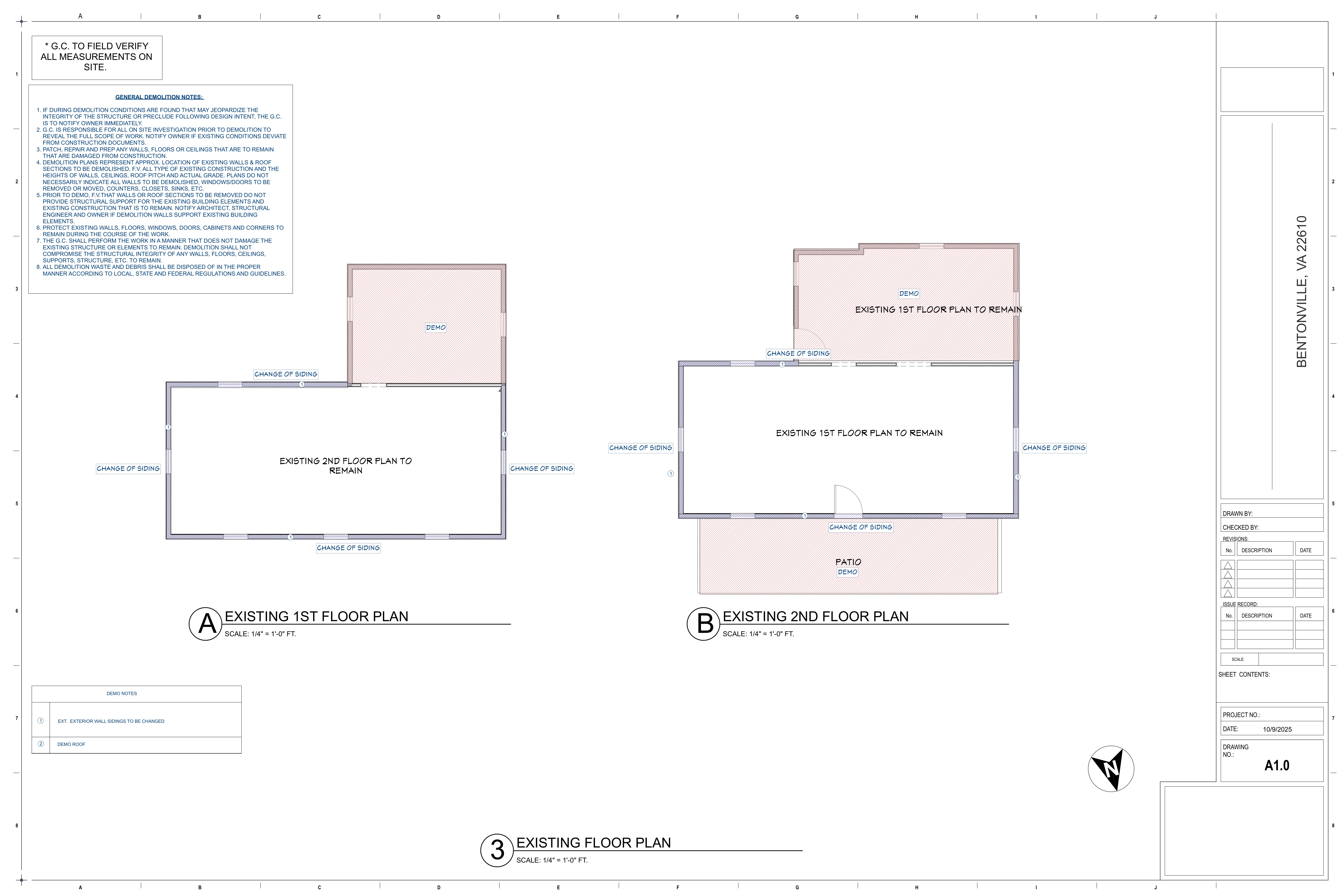
Existing conditions verified through point-cloud tracing, establishing a measured baseline for demolition and proposed new construction.
4. The Contractor's ROI: Skipping the Re-Trip
Consider the real cost of measuring a house the old way:
- 2 guys on site for 3 hours = 6 man-hours ($450 labor cost).
- 1 guy drives back out three days later because he forgot the ceiling height in the utility closet = 2 hours + fuel ($175).
- Total cost = $625+ per project, plus lost momentum.
With mobile LiDAR, the project super walks the job once, takes 15 minutes, and uploads the file before getting back in the truck. You never have to re-visit the site to double-check a forgotten measurement—because the entire physical space is preserved digitally forever.
5. How to Send Us Your Scans
- Download a free LiDAR scanning app (such as Polycam, Canvas, or SiteScape) on any iPhone 12 Pro through 16 Pro or iPad Pro.
- Walk the interior rooms, save the project, and export the file as an OBJ, E57, or LAS file (or simply share the Polycam/Canvas cloud web link).
- Email the link to our drafting team. Within 2 to 4 business days, you receive a complete, layered AutoCAD DWG and plotted PDF as-built drawing set with floor plans, exterior elevations, and window schedules.
Send us a scan for a free quote or email admin@hearthplans.com.
Related Engineering Calculators & Permit Services
Coordinate your project drawings with these free interactive engineering calculators or request complete permit-ready drafting sheets from our studio.
Interactive Permit Calculators
Interactive 3D Digital Twin Viewer
Inspect, walk through, and dimension 3D architectural digital twins directly in your browser with real-time solar daylighting.
NEC 220 Panel Schedule Calculator
Draft matching electrical schedules for your as-built and proposed remodel drawings.
Permit Drafting Services
Scan to BIM & LiDAR As-Built Drafting
Convert iPhone LiDAR point clouds and Matterport scans into editable Chief Architect (.plan) or Revit (.rvt) models.
Architectural Drafting in DWG and PDF
Production drafting for floor plans, exterior elevations, cross-sections, and window/door schedules.